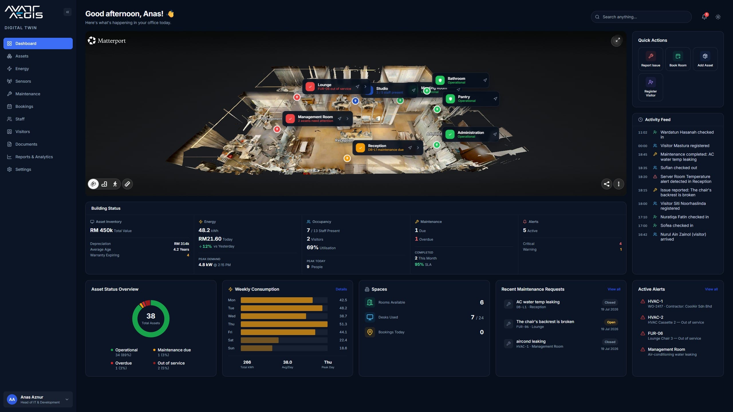
Avant Aegis operates a fully functional digital twin across its own office, combining Matterport Pro3 spatial capture, BIM and asset information, system integration and a custom operational application.
For many small and medium property owners, the idea of a digital twin sounds valuable but difficult to implement. The usual image is a complex building information model connected to multiple building systems, specialist analytics and a substantial implementation programme.
That can be the right approach for a large or technically complex asset. It is not the only possible starting point.
Avant Aegis has deployed and operates a fully functional digital twin across our own office. The live application supports our internal operations by connecting a photorealistic spatial environment with asset information, IoT telemetry, energy monitoring and facilities-management workflows.
This operational deployment brings together four areas of Avant Aegis capability: spatial capture, BIM and asset information, system integration, and custom application development. It also demonstrates a practical delivery route for existing properties where the owner needs usable operational intelligence without first recreating every part of the building as a highly detailed as-built BIM model.
To protect private and confidential information, the public video uses a controlled historical snapshot rather than exposing current internal operating data. The displayed values are drawn from actual data and serve the application walkthrough, but they are not live at the time of playback. The application and its live operational connections remain fully functional.
Four Avant Aegis Capabilities in One Operational System
1. Spatial Capture
Avant Aegis owns and operates Matterport Pro3 hardware and its supporting capture rig as part of our reality-capture service. For the office deployment, Pro3 LiDAR capture and high-resolution imagery provide the navigable visual and spatial foundation.
This gives users an immediate understanding of the existing space and allows information to be tied to recognisable physical locations. Depending on the project purpose, the capture can also support survey review, asset identification, record documentation and subsequent BIM production.
For larger indoor environments, the same registered spatial foundation can be developed into a navigation and wayfinding layer that connects entrances, floors, rooms, facilities, service areas and selected assets.
2. BIM and Asset Information
BIM capability provides the structured information layer behind the visual environment. Spaces, maintainable assets, identifiers, properties, documents and system relationships can be developed to the level required for the owner’s operational use cases.
Avant Aegis can combine reality capture with scan-to-BIM, verified record modelling and Asset Information Model development where structured geometry, formal deliverables or deeper system relationships are required. The objective is to apply the right level of model and information detail, rather than creating data that the operator will not use.
3. System Integration
The office application brings IoT sensors, energy readings, CCTV, asset records and operational workflows into one connected environment. Spatial context allows each feed or record to be associated with the relevant equipment, room or location.
For client deployments, integration can be configured around the available systems and interfaces, including compatible sensors, meters, BMS, CCTV, CMMS, CAFM, booking tools and other authorised data sources.
4. Custom Application Development
Avant Aegis designed and developed the application interface, modules, data structures and workflows used in the office deployment. The platform is therefore not limited to a generic three-dimensional viewer or a fixed dashboard.
Custom application development allows the digital twin to reflect the owner’s users, assets, operational priorities, permissions, reports and existing technology environment. Modules can be configured around the decisions and processes the client actually needs to manage.
A Spatial Model Becomes More Useful When It Is Connected
A navigable three-dimensional scan is valuable for orientation, remote inspection and visual record-keeping. On its own, however, it is still primarily a representation of the space at the time it was captured.
The Digital Twin Consortium defines a digital twin as a data-driven virtual representation of real-world entities and processes with synchronised interaction at a defined frequency and fidelity. The important distinction is therefore not the visual quality of the model. It is the connection between the digital environment and the physical asset.
In the Avant Aegis office application, the captured office provides spatial context. Operational information makes that context actionable:
- assets are registered and placed at their physical locations;
- static records sit alongside changing status and telemetry;
- energy use can be viewed by equipment and space;
- environmental sensors report current conditions;
- maintenance issues become trackable work orders; and
- rooms, occupants and visitors can be managed through related operational modules.
Instead of asking a facility manager to interpret separate floor plans, spreadsheets, dashboards, camera systems and document folders, the application brings selected information into one spatially organised interface.
What the Operational Office Application Shows
The short application walkthrough moves from a whole-building dashboard into increasingly specific operational views.
1. Dashboard: A Building-Wide Operational View
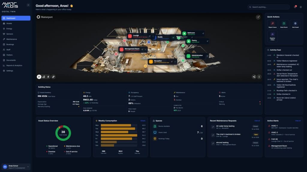
The dashboard places the captured office at the centre of the interface. Status markers identify rooms and operational conditions directly on the spatial model.
Around that view, the application consolidates key information including:
- asset condition and status;
- current energy use;
- occupancy and space utilisation;
- maintenance items;
- active alerts;
- recent operational activity; and
- quick actions such as reporting an issue, booking a room, adding an asset or registering a visitor.
The purpose is not to display every available data point. It is to give an operator a rapid understanding of what requires attention and a direct route to the relevant record or location.
2. Asset Module: From Register to Physical Context
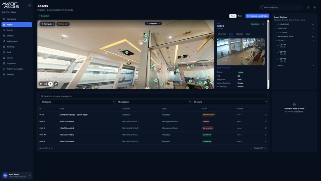
The Asset module combines a searchable asset register with the three-dimensional office map. Assets can be grouped by categories such as IT equipment, furniture, electrical systems, HVAC, security and spaces.
Each record can bring together:
- asset identifier and category;
- physical location;
- operational or maintenance status;
- manufacturer, model and installation information;
- warranty and responsible-party details;
- live telemetry where available;
- related O&M information, attachments and documents; and
- service, fault or maintenance history.
The CCTV example demonstrates the value of connecting an asset record to its actual position. The user can navigate to the camera in the captured space, inspect its metadata and status, and open its live feed from the same context.
This relationship is useful beyond CCTV. A facility technician could select an HVAC unit, energy meter or distribution board, confirm where it is, review its documentation and see its latest status before attending the location.
3. Energy Module: Connecting Consumption to Equipment and Space
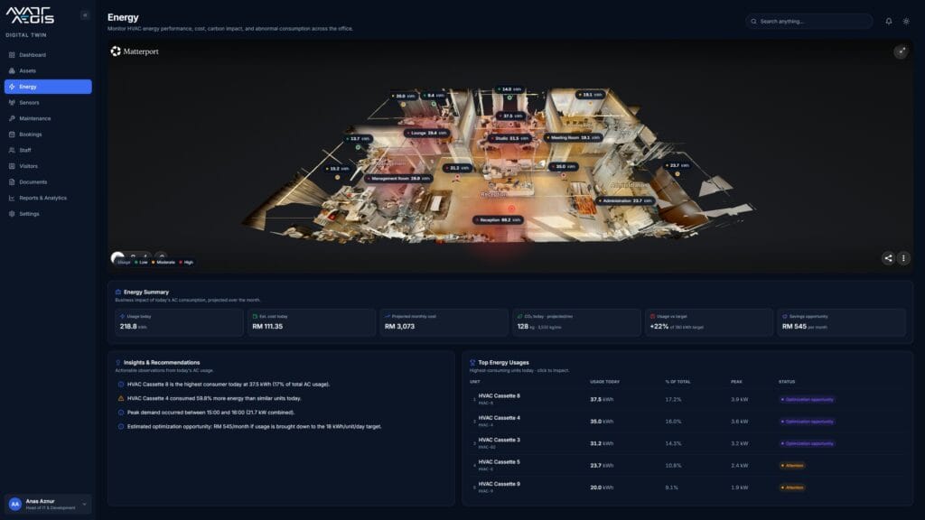
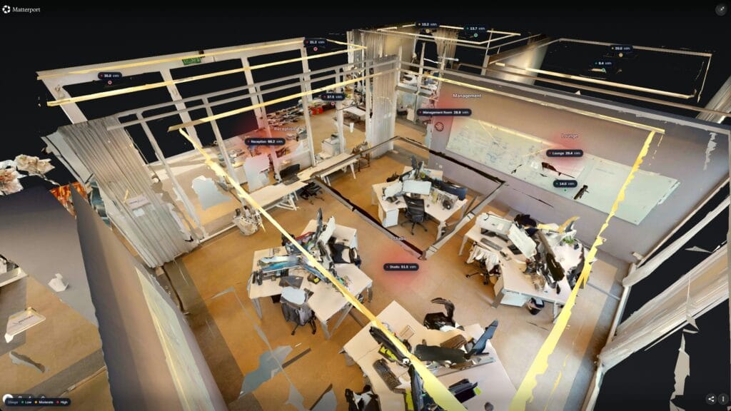
The Energy module moves energy information from a detached chart into the building itself. A spatial heatmap shows relative consumption across rooms and equipment, while selectable markers lead to more detailed performance information.
The application includes:
- live or recent readings for individual energy-consuming assets;
- whole-building and equipment-level consumption summaries;
- usage by space;
- daily profiles and peak-demand visibility;
- room, supply and setpoint temperature trends;
- estimated cost and carbon indicators;
- high-consumption rankings; and
- optimisation observations based on the available data.
This reflects the wider role of an energy management information system. The US Department of Energy describes EMIS capabilities as including the centralisation, normalisation and visualisation of facility data, interval-meter analytics, fault detection and operations-and-maintenance optimisation.
The critical step is turning a reading into a decision. If energy use remains high when a space is unoccupied, for example, the system can flag a possible scheduling or control issue. If an HVAC unit repeatedly consumes more than comparable units under similar conditions, it becomes a candidate for inspection.
These observations are decision support, not automatic proof of savings. Recommendations depend on reliable meters, timestamps, equipment relationships, operating schedules, occupancy data, tariffs, baselines and agreed calculation rules. As the Department of Energy also notes, these systems are human-in-the-loop tools: identified measures only create value when people assess and act on them.
4. Sensor Module: Current Conditions at a Glance
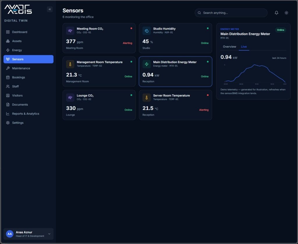
The Sensor module presents a card-based view of environmental and equipment readings. The application includes:
- carbon dioxide;
- humidity;
- room and server-room temperature; and
- an electrical energy meter.
Each card shows the sensor, its location, current value and operational or alert status. This provides a simple monitoring view for users who do not need to enter the three-dimensional environment for every check.
For each deployment, thresholds are defined according to the sensor type, calibrated range, space use and operational policy. A red status should represent a traceable rule, not simply a visual warning.
5. Maintenance Module: Turning Issues into Managed Work
The Maintenance module shows work orders grouped by status, including open, in-progress and closed items. Records can be associated with the affected asset and location so that the issue, equipment information and spatial context remain connected.
The workflow supports:
- issue reporting;
- responsibility and priority assignment;
- supporting photographs or documents;
- planned and actual dates;
- status updates;
- completion evidence; and
- a maintenance history for the asset.
The value is continuity. An alert or reported problem should not end as a notification that someone must manually re-enter into another system. It should become a controlled task with an owner and an auditable outcome, whether the workflow remains inside the application or connects to an existing CMMS or CAFM platform.
6. Booking Module: Managing Shared Space
The Booking module manages room and desk reservations, including the booked space, user, date, time and status. Because the room also exists in the spatial model, a user can understand its location and surrounding context rather than selecting only from a name in a list.
For client deployments, the module can be configured around the organisation’s operating needs, including availability rules, capacity, equipment, approval requirements, calendar integration or check-in status.
7. Staff Module: Occupancy with Operational Context
The application includes a Staff module for directory information and occupant work status. It helps authorised users understand who is working on site, who is remote, where teams are normally based and how workplace demand changes over time.
This information should be limited to a defined business purpose. Access, retention and visibility must be designed with employment policy, privacy and cybersecurity requirements in mind.
8. Visitor Module: A Connected Visitor Register
The Visitor module supports registration and visit status, with visitor activity also appearing in the wider operational feed. The connected workflow includes host details, expected arrival, check-in, check-out and the relevant destination.
As with staff and CCTV information, visitor data requires proportionate access controls, retention rules and an auditable operating procedure.
9. Navigation and Wayfinding: Guiding People Through Large Indoor Complexes
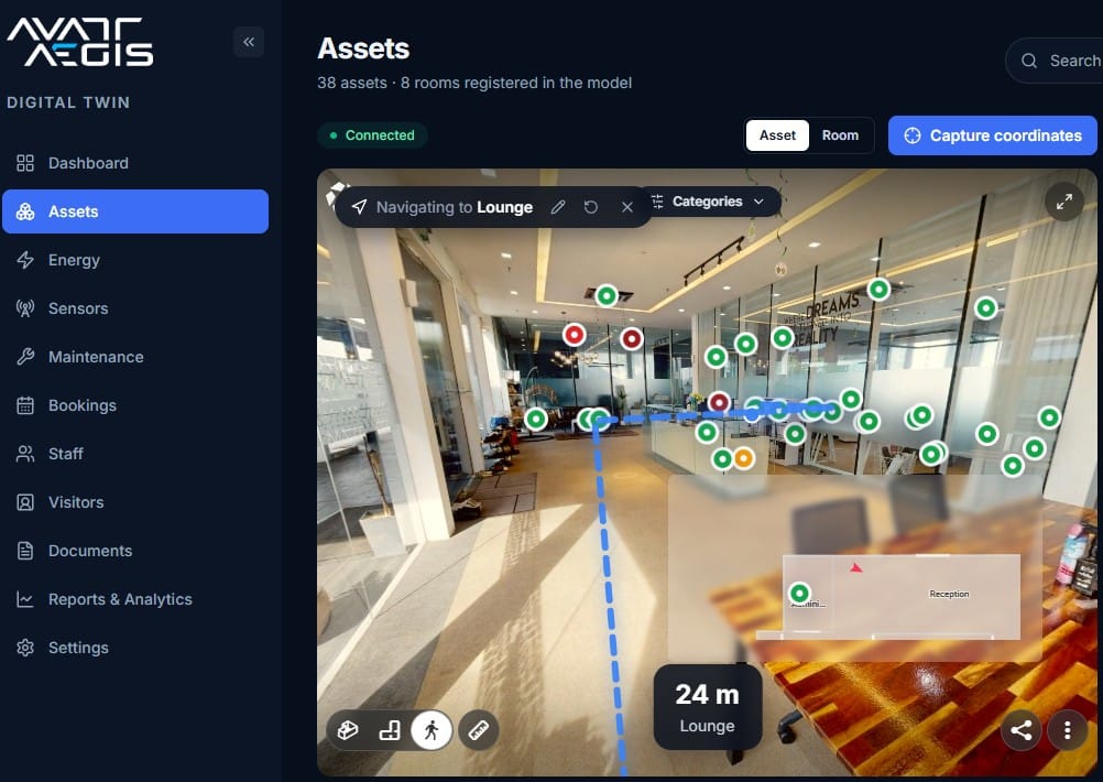
The same spatial environment can support indoor navigation and wayfinding for larger or more complex properties. This may include offices, campuses, hospitals, shopping centres, hotels, transport facilities and other multi-level buildings where visitors, occupants or service teams need clear guidance to a destination.
A configured wayfinding solution can:
- guide users from an entrance or current location to a room, facility or service point;
- provide routes between floors, wings or connected buildings;
- distinguish public, staff, service and restricted circulation routes;
- identify lifts, stairs, reception points, amenities and emergency facilities;
- provide accessible routes that avoid stairs or other defined barriers;
- direct maintenance teams to the physical location of an asset or work order; and
- reflect temporary closures or route restrictions when connected operational information is available.
Delivery requires more than displaying the three-dimensional capture. The routing network, destinations, floor transitions, access rules, accessible paths and update responsibilities must be structured and maintained. Where live indoor positioning is required, the solution may also integrate compatible positioning technologies, subject to the building environment, required accuracy, user devices and available infrastructure.
This capability extends the digital twin from an operational information environment into a location-aware service for occupants, visitors and facilities teams.
Why Existing Buildings Need a Different Starting Point
New-build projects can plan their operational information during design and construction. Models, asset identifiers, equipment data and handover documents can be specified before the building is occupied.
Existing buildings often begin from a different position:
- drawings may be incomplete or outdated;
- the final installed condition may differ from the record;
- asset data may sit in spreadsheets, labels, invoices or individual staff knowledge;
- equipment documents may not be linked to the assets they describe; and
- operational systems may use different naming conventions.
Creating a complete as-built BIM model retrospectively can address some of these problems, but it also requires capture, interpretation, modelling, classification and verification. A long-standing review of BIM for existing buildings identified the effort of converting captured conditions into semantic BIM objects as a major implementation challenge (Volk, Stengel and Schultmann).
Reality capture offers another entry point. Research into reality-model-based facilities management for existing buildings has explored how point-cloud and spatial environments can support facility information where complete historical records are unavailable.
The important word is entry point. A reality-capture model does not automatically replace every purpose of an as-built BIM model.
Reality Capture and As-Built BIM Serve Different Information Needs
| Consideration | Reality-capture spatial foundation | As-built BIM / Asset Information Model |
|---|---|---|
| Primary strength | Photorealistic navigation and direct visual context | Structured objects, properties, systems and relationships |
| Starting information | Captured visible conditions | Survey data, verified records and interpreted model content |
| Upfront effort | Can reduce manual modelling when a navigable spatial base is sufficient | Requires modelling, information authoring and validation to an agreed scope |
| Typical operational use | Remote orientation, asset location, issue context and visual mapping | Formal asset information, analysis, documentation, change planning and system-level data exchange |
| Precision | Depends on the capture equipment, control, processing and validation | Depends on the survey source, modelling method, tolerances and verification |
| Limitations | Does not inherently identify concealed systems or create semantic building objects | Can cost more to produce and maintain than the operational use case justifies |
Avant Aegis delivers both reality-capture and BIM services, allowing these layers to be combined rather than treated as competing options. Matterport Pro3 capture can provide rapid, photorealistic spatial context, while BIM provides structured geometry, assets and system relationships wherever the operational use case requires them.
For many small and medium properties, the most proportionate solution is a hybrid:
- use reality capture to establish the visual and spatial base;
- register only the spaces and assets that matter to operations;
- attach the required static information;
- connect selected live data sources; and
- add structured BIM or system information where a defined use case requires it.
This approach avoids two extremes: a disconnected three-dimensional tour with little operational value, and an over-specified information model that costs more to produce and maintain than the owner can use.
It can be more cost-efficient than developing a comprehensive retrospective BIM model when the required outcome is spatial asset access, monitoring and workflow coordination. Actual cost still depends on asset size, capture conditions, accuracy requirements, number of assets, data quality, integrations, software, cybersecurity and ongoing support. The correct comparison is therefore not “scan versus BIM” in isolation. It is the cost of producing and maintaining the information needed for an agreed operational purpose.
A Practical Adoption Path for Small and Medium Property Owners
A digital twin does not need to connect every room, asset and sensor on day one. A staged implementation can establish value while keeping the information scope manageable.
Stage 1: Define the Operational Questions
Start with a small number of decisions the system should improve:
- Where is a maintainable asset?
- Is it operational?
- What document or service information is required?
- Which spaces or systems use the most energy?
- What issues are open, and who is responsible?
The Gemini Principles summarise this discipline well: a digital twin should have clear purpose, be trustworthy and function effectively.
Stage 2: Capture and Organise the Space
Create a spatial record appropriate to the intended use. Avant Aegis can perform this capture using our Matterport Pro3 hardware and rig, with the method, access, areas included, accuracy expectations, known blind spots and update process defined for the project.
Visible geometry should not be treated as verified concealed information. Where survey-grade dimensions, engineering interfaces or contractual as-built deliverables are required, additional survey control, validation or BIM production may be necessary.
Stage 3: Register Priority Assets
Begin with the assets that create the greatest operational need: HVAC equipment, electrical distribution, meters, security devices or other maintainable systems.
Agree the minimum fields, identifiers, classifications, document links and ownership rules before loading data. More fields do not automatically mean better information; required fields that remain current are more useful than a larger, unreliable dataset.
Stage 4: Connect Selected Live Data
Add sensors or system integrations only where the data supports a decision. The required update frequency may differ by use case. An environmental sensor may report frequently, while an asset document changes only when revised.
Integration scope should define the source system, interface, units, timestamps, data owner, error handling, retention and what happens when a feed becomes unavailable.
Stage 5: Connect the Operational Workflow
Decide how the application relates to existing processes and systems. Maintenance may remain in a CMMS; bookings may connect to a calendar platform; energy data may come from meters, a BMS or an energy platform.
The twin should reduce duplication, not become another isolated system that staff must update manually.
Stage 6: Measure, Review and Expand
Review whether the first use cases improve response time, information access, reporting or decision quality. Expand to further assets, spaces or integrations only where the evidence and operating capacity justify it.
Information Governance Is Part of the Solution
The technical interface is only one part of a dependable operational environment.
ISO 19650-3 specifies an information-management process for the operational phase of assets and can be applied to organisations and assets of different types and sizes. Applying that principle proportionately means defining what information is required, who owns it, how it is reviewed and how it remains current.
The application also brings together information that can be operationally sensitive: camera feeds, building layouts, asset locations, staff status, visitor records and system telemetry. NIST’s guidance on digital-twin security and trust emphasises that cybersecurity and trust must be considered alongside digital-twin functions.
A client implementation should therefore address:
- role-based access;
- identity and authentication;
- permissions by module and data type;
- data encryption and secure interfaces;
- logging and audit trails;
- CCTV, staff and visitor privacy;
- retention and deletion rules;
- system availability and recovery;
- sensor and source-data quality; and
- responsibility for updates and approvals.
These controls do not sit outside the digital twin. They determine whether people can trust and safely use it.
What This Operational Deployment Establishes
The fully operational Avant Aegis office digital twin demonstrates both the delivery method and the integrated capability that Avant Aegis can bring to an existing small or medium property:
- owned and operated Pro3 reality-capture capability provides an intuitive spatial foundation;
- BIM and structured asset information connect spaces, equipment, documents and system relationships;
- system integration places live feeds and operational records in the context of equipment and location;
- custom application development turns the information into role-appropriate dashboards, modules and workflows;
- energy and environmental information can be viewed at building, space and asset level;
- issues move into connected maintenance workflows; and
- booking, staff and visitor management operate within the same environment.
The same spatial, BIM and application-development capabilities can also be extended into indoor navigation and wayfinding for larger complexes, with routes and access logic configured to suit the property and its users.
It does not imply that every project needs the same modules, that every reality-capture model is a substitute for verified as-built BIM, or that a dashboard alone will deliver energy or maintenance savings.
The useful outcome is a right-sized digital twin: enough spatial, asset and operational information to support the owner’s decisions, with a clear path to add detail and integrations as requirements develop.
Start with the Building You Already Have
Digital-twin adoption should not be limited to new landmark projects or large property portfolios. Existing buildings can begin with a focused operational use case, an appropriate spatial foundation and a manageable set of connected information.
For a small or medium property owner, that can mean starting with one office, one floor or one group of critical assets. The objective is not to reproduce every piece of building information. It is to create a dependable connection between the physical space, the assets within it and the people responsible for operating it.
That is the delivery approach represented by the Avant Aegis office application: capture the existing environment, structure the required BIM and asset information, connect the systems that matter, and deliver the result through an application designed around real operational workflows.